
Prince Charles: 'direct relationship' between ecosystems and the economy
Jeremy Hance
mongabay.com
February 09, 2011
At an EU meeting in Brussels, dubbed the Low Carbon Prosperity Summit, the UK's Prince Charles made the case that without healthy ecosystems, the global economy will suffer.
"We have to see that there is a direct relationship between the resilience of Nature's ecosystems and the resilience of our national economies," he told Members of the European Parliament (MEPs), business leaders, and other policy makers. "If the fabric of the Earth's life-support system fragments, as it appears it may be starting to do; if those systems become weak or even collapse—essentially, if Nature's capital loses its innate resilience—then how long does it take for our economic capital and economic systems to lose their resilience too?"
He added: "I cannot see how we can possibly maintain the growth of GDP in the long term if we continue to consume our planet as voraciously as we are doing."
The heir to the English throne also attacked climate change deniers for their "corrosive effect on public opinion".
He stated that such self-described skeptics "deny the vast body of scientific evidence that shows beyond any reasonable doubt that global warming has been exacerbated by human industrialized activity."
In 2007 the Intergovernmental Panel on Climate Change (IPCC) concluded that it was 'very likely' (over 90%) that human activities are the primary cause of warming over the past century. Since the industrial revolution, the Earth has warmed on average approximately 1.4 degrees Fahrenheit. The last decade was the warmest since record keeping began, and 2010 among the world's warmest years.
"I would ask how these people are going to face their grandchildren and admit to them that they failed their future; that they ignored all the clear warning signs," he continued. "I wonder, will such people be held accountable at the end of the day for the absolute refusal to countenance a precautionary approach for this plays a most reckless game of roulette with the future inheritance of those who come after us?"
Prince Charles also said that environmentalists must change their message and focus on the many benefits of living sustainably.
"If we are constantly told that living environmentally friendly lives means giving up all that makes life worthwhile, then it is no surprise that people refuse to change," he said.
Comments
Comments: Prince Charles: 'direct relationship' between ecosystems and the economy
I agree with your views Prince Charles.
Here is more information on Economics of Ecosystems:
The Economics of Ecosystems and Biodiversity (TEEB) study is an international initiative to draw attention to the global economic benefits of biodiversity. Its objective is to highlight the growing cost of biodiversity loss and ecosystem degradation and to draw together expertise from the fields of science, economics and policy to enable practical actions. TEEB aims to assess, communicate and mainstream the urgency of actions through its five deliverables; D0: science and economic foundations, policy costs and costs of inaction, D1: policy opportunities for national and international policy-makers, D2: decision support for local administrators, D3: business risks, opportunities and metrics and D4: citizen and consumer ownership.
One motive for the study was to establish an objective global standard basis for natural capital accounting. Various estimates establish the cost of biodiversity and ecosystem damage expected to cost 18% of global economic output by 2050 and currently at over US$2T (for the largest 3000 companies according to Trucost) , with some estimates as high as US$6T/year . The World Bank in particular has led recent efforts to include the cost of biodiversity and climate harm in national accounts .
Its sponsors declare TEEB to be a "major international initiative to draw attention to the global economic benefits of biodiversity, to highlight the growing costs of biodiversity loss and ecosystem degradation, and to draw together expertise from the fields of science, economics and policy to enable practical actions moving forward." In October 2010 it released its report "Mainstreaming the Economics of Nature: a synthesis of the approach, conclusions and recommendations of TEEB" and launched the Bank of Natural Capital to communicate its findings to the general public.(Source: Wikipedia).
Dr.A.Jagadeesh Nellore(AP),India
Dr.A.Jagadeesh
19 February 2011
Brazil to help African, Asian countries in satellite-based forest monitoring
mongabay.com
December 03, 2010
Brazil will provide technical assistance to help tropical countries improve their forest monitoring capabilities, according to an official with the South American country's satellite agency.
Carlos Nobre, head of the Earth System Science Center at the National Institute for Space Research (INPE), said Brazil will share "knowledge and technology" on its leading satellite-based deforestation monitoring system with countries in Africa and Southeast Asia.
"The goal is to train countries in geospatial information systems so they can eventually adapt and benefit from the REDD system that will be defined under the UN Convention on Climate Change," said Nobre in a statement.
INPE's system tracks deforestation, degradation, and associated emissions.
Nobre added that INPE will also help other countries with climate modeling.
INPE's engagement comes under an agreement Brazil signed with U.N. Food and Agriculture Organization (FAO) at COP-15 in Copenhagen to support the UN-REDD program, according to Gilberto Camara, the director INPE.
"With the support of FAO, INPE is committed to train remote sensing specialists from developing nations in the methods and techniques we use," Camara told mongabay.com. "The purpose is to allow all interested nations to build the same type of monitoring system we have.
Camara added that INPE has built a new state-of-the-art data center in Belem to support its "data democracy" initiative, which includes national and international capacity building.
Comments: Brazil to help African, Asian countries in satellite-based forest monitoring
It will greatly help African and Asian Countries the collaboration in satellite based forest monitoring. It will also check smuggling of forest wealth.
Dr.A.Jagadeesh Nellore(AP),India
DR.A.Jagadeesh
Coal's true cost in the US: up to half a trillion Jeremy Hance
mongabay.com
February 20, 2011
According to the global market coal is cheap, yet a new study in the Annals of the New York Academy of Sciences finds that the hidden costs of coal are expensive, very expensive. Estimating the hidden costs of coal, such as health and environmental impacts, the study found that burning coal costs the US up to $523 billion a year. Dubbed 'externalities' by economists, the paper argues that these costs are paid by the American public.
"This is not borne by the coal industry, this is borne by us, in our taxes," Paul Epstein, a Harvard Medical School instructor and the associate director of its Center for Health and the Global Environment, the study's lead author, told Reuters. "The public cost is far greater than the cost of the coal itself. The impacts of this industry go way beyond just lighting our lights."
Some of the costs measured by the study include higher rates of cancer and other diseases from pollution, accidental deaths of coal miners, the loss of tourism revenue after coal mountains have been devastated by mining, and the impact of climate change. The study breaks down the costs as such: $74.6 billion paid for by Appalachian communities in direct health risks, injuries, and deaths; $187.5 billion from air pollutants; $8.8 billion in abandoned mine areas; while climate change impacts could vary from $61.8 billion to $205.8 billion.
"Accounting for these 'hidden costs' doubles to triples the price of electricity from coal per kWh, making wind, solar, and other renewable very economically competitive. Policymakers need to evaluate current energy options with these types of impacts in mind. Our reliance on fossil fuels is proving costly for society, negatively impacting our wallets and our quality of life," Epstein said in a press release.
Currently coal accounts for 45% of the US's power.
Comments: Coal's true cost in the US: up to half a trillion
Of late there is wide criticism on coal powered plants and the hidden costs as compared to Renewable Energy.
Let us examine the Coal powered plants and the associated issues:
“Coal ash is a byproduct of coal combustion, created when coal is burned to generate energy. Coal-fired power plants are major producers of coal ash worldwide. In some regions, the components of this byproduct can be re-used in a variety of products, including concrete, while the remainder must be isolated and stored to prevent pollution. Failure to contain coal ash properly can lead to catastrophic problems; a coal ash spill in Tennessee in 2008 generated over one billion United States Dollars (USD) in damage.
The constituents of coal ash vary, depending on the original source of the coal. The major ingredient is minerals which could not be burned, including an assortment of radioactive isotopes. Bottom ash, found at the bottom of boilers, is a thick, coarse assortment of minerals. Fly ash is much finer, composed of fine particles which have bonded together. Boiler slag is another form of coal ash. In facilities where filters and scrubbing systems are in place, a product known as flue gas desulfurization (FGD) gypsum is also generated and needs to be handled with care.
When coal ash is removed from a power generation facility, it is classically stored, often in a landfill. Some of the ash can be sold for other uses, with utilization rates varies, depending on the component. Fly ash, for example, can be very useful, and up to 75% of the fly ash from a power plant may be reused in concrete and other products.
Environmental studies have shown that coal ash can be quite dangerous. It is highly radioactive in some cases, with poor environmental controls which may not entirely prevent contamination. Unlike a nuclear facility, which is carefully monitored and must follow a series of laws to limit radiation exposure, a coal fired power plant can release radioactive material into the surrounding environment and handle its ash without safety measures comparable to those used to control nuclear waste. Coal ash also contains dioxins and other toxins which can be dangerous when released into the environment.
Coal ash disposal is a serious environmental concern in some regions of the world. The problem has been inadvertently complicated by environmental laws mandating more trapping of pollutants; the collection of pollutants in the stacks of power plants prevents them from being released into the environment, but generates more ash which must be properly disposed of. Some nations have initiated government programs to monitor coal fired power plants and develop recommendations for handling byproducts of combustion to keep the surrounding environment cleaner”(Source: What is Coal Ash? Wise GEEK).
Coal Powered Plants in US:
There are currently 1470 generators at 617 facilities in the United States alone that use coal as the major source of energy to generate electricity. Of these facilities, 141 are considered industrial, institutional or commercial sites that consume most of the electricity produced on-site. The remaining 476 sites are identified as “power plants” owned by electric utilities and independent power producers that generate and sell electricity as their primary business. The
primary goals that drive these power plants are increasing efficiency and throughput, reducing emissions of pollutants, and maintaining a high level of safety.
U.S. Coal-Fired Power Production in the Global Context
In 2007, the U.S. produced approximately 2,118,000 GWh (gigawatt hours) of electricity from coal (one GWh is the amount of power produced by a 1,000 MW power plant running for one hour), accounting for about a quarter of the world's coal-fired electricity:
| Country | 2007 Coal Power Prod. | % of World Total |
| 2,656,000 GWh | 32.3% | |
| U.S.A. | 2,118,000 GWh | 25.7% |
| 549,000 GWh | 6.7% | |
| 311,000 GWh | 3.8% | |
| 311,000 GWh | 3.8% | |
| 247,000 GWh | 3.0% | |
| 194,000 GWh | 2.4% | |
| 171,000 GWh | 2.1% | |
| 170,000 GWh | 2.1% | |
| 148,000 GWh | 1.8% | |
| All Other Countries | 1,353,000 GWh | 16.4% |
| World Total | 8,228,000 GWh | 100% |
(Source: “Key World Energy Statistics 2009”, International Energy Agency, 2009, p. 25.)
When stringent safety measures are taken at Coal based thermal plants in US, the figures quoted by antagonists of Coal fired production power plants is not clear. If the health hazards due to Coal fired power plants are many, why there is no action on them in an advanced country like US?
Dr.A.Jagadeesh Nellore (AP), India
Dr.A.Jagadeesh
21 February 2011
Brazil to help African, Asian countries in satellite-based forest monitoring
mongabay.com
December 03, 2010
Brazil will provide technical assistance to help tropical countries improve their forest monitoring capabilities, according to an official with the South American country's satellite agency.
Carlos Nobre, head of the Earth System Science Center at the National Institute for Space Research (INPE), said Brazil will share "knowledge and technology" on its leading satellite-based deforestation monitoring system with countries in Africa and Southeast Asia.
"The goal is to train countries in geospatial information systems so they can eventually adapt and benefit from the REDD system that will be defined under the UN Convention on Climate Change," said Nobre in a statement.
INPE's system tracks deforestation, degradation, and associated emissions.
Nobre added that INPE will also help other countries with climate modeling.
INPE's engagement comes under an agreement Brazil signed with U.N. Food and Agriculture Organization (FAO) at COP-15 in Copenhagen to support the UN-REDD program, according to Gilberto Camara, the director INPE.
"With the support of FAO, INPE is committed to train remote sensing specialists from developing nations in the methods and techniques we use," Camara told mongabay.com. "The purpose is to allow all interested nations to build the same type of monitoring system we have.
Camara added that INPE has built a new state-of-the-art data center in Belem to support its "data democracy" initiative, which includes national and international capacity building.
Comments: Brazil to help African, Asian countries in satellite-based forest monitoring
It will greatly help African and Asian Countries the collaboration in satellite based forest monitoring. It will also check smuggling of forest wealth.
Dr.A.Jagadeesh Nellore(AP),India
DR.A.Jagadeesh
Rhett A. Butler, mongabay.com
February 08, 2011
DEGRAD, INPE's system for measuring forest degradation in the Amazon rainforest.
Perhaps unsurprisingly, the world's best deforestation tracking system is found in the country with the most rainforest: Brazil.
Following international outcry over immense forest loss in the 1980s, Brazil in the 1990s set in motion a plan to develop a satellite-based system for tracking changes in forest cover. In 2003 Brazil made the system available to the world via its web site, providing transparency on an issue that was until then seen as a badge of shame by some.
Since then Brazil has become recognized as the standard-bearer for deforestation tracking and reporting—no other country offers the kind of data Brazil provides.
Brazil has two systems for tracking deforestation: PRODES (Program to Calculate Deforestation in the Amazon) and DETER (Real-time Detection of Deforestation), which allow it to rapidly identify where deforestation is occurring. PRODES, which has a sensitivity of 6.5 hectares, provides Brazil’s annual deforestation estimates (measured each August) while DETER, which has a coarser resolution of 25 ha, is a year-round alert system that updates IBAMA, Brazil’s environmental protection agency, every two weeks. This gives authorities the technical capacity—although not necessarily the political will—to combat deforestation as it occurs.
Brazil's deforestation monitoring system was developed by INPE, the National Institute for Space Research, the country's equivalent of NASA, under its Earth Observation program. INPE also runs other programs focused on space science, weather forecasting, climate change modeling, and space engineering. Brazil is currently build four earth observation satellites, including two in cooperation with China.
| |
|
Space engineer Gilberto Camara has overseen much of INPE's earth sensing work, first as head of INPE's Image Processing Division, then as head of INPE's Earth Observation, and since 2005 as director of INPE. During his watch, INPE has released several new exciting capabilities, including DETER, a program to monitor ecosystems outside the Amazon, tools to track forest degradation due to logging and fire, and a way to measure emissions from deforestation. INPE recently announced a LIDAR (LIght Detection And Ranging)-based system that will provide more precision, sensing even through smoke and cloud cover.
In a January interview with mongabay, Dr. Camara explained how he went from a boy in northeastern Brazil to director of INPE and discussed INPE's deforestation monitoring and other projects.
AN INTERVIEW WITH INPE'S GILBERTO CAMARA
mongabay: How did you become interested in space research?
Gilberto Camara: In 1969, when I was 13 years old, two events shaped my future: the Apollo 11 landing on the moon and the movie "2001: A Space Odyssey". I remember coming home bowled over after watching "2001". At the time, I lived in Fortaleza, a resort town on the hot and dry Brazilian Northeast. I decided I would study to become a space engineer.
mongabay: What was your path to becoming director of INPE?
Gilberto Camara: After I decided I would be a space engineer, I had to study hard to be accepted at the Aeronautics Technology Institute (ITA), which is Brazil's top school for aerospace engineers, located near São Paulo, in the Southeast. I managed to get accepted at ITA, graduating with a BS in Electrical Engineering in 1979. Then, I joined INPE in 1980 as an engineer, and earned an MsC and a PhD in Computer Science at INPE. I then decided to focus on Geoinformatics and Image Processing as my main research areas. From 1991 to 1996, I was head of INPE's Image Processing Division. From 2011 to 2005, I was head of INPE's Earth Observation area. In 2005, I was appointed director of INPE by a search committee for a four year mandate. In 2009, I was selected (again by a search committee) to serve a second four-year mandate.
mongabay: What are some highlights of INPE's main programs?
| |
|

Gilberto Camara: INPE's main areas are Space Science, Earth Observation, Weather Forecasts, Earth System Science, and Space Engineering. In Space Science, we are developing a Space Weather program, that aims to provide information about conditions in near-Earth space within the magnetosphere and the ionosphere. In Earth Observation, we focus on land use monitoring, especially deforestation in Amazonia and sugarcane expansion in the central part of Brazil. As for Weather, we are the main center for Numerical Weather Forecasting in Brazil, using a CRAY supercomputer (currently ranked 29th in the world's top supercomputers). Our Earth System Science center focuses on forecasts on the impact of Climate Change in Brazil. In Space Engineering, we are currently building four Earth Observation satellites (two in cooperation with China).
mongabay: What spurred Brazil to develop its Amazon deforestation monitoring system?
Gilberto Camara: It started with the need to respond to international criticism, especially in the years preceding the 1992 Earth Summit in Rio. Then, the system started to be used as a tool for policy-making, especially after all data was released on the web (after 2003).
mongabay: How does the monitoring system work?
| |
|
Gilberto Camara: We currently provide three different types of information:
(a) Fires: produced daily from data provided by MODIS, GOES and NOAA satellites. An automatic algorithm detects areas likely to be on fire and flags fire occurrences which are then put on the web.
(b) Near-real time deforestation (DETER): produced every 15 days from MODIS and AWIFS-ResourceSat data. Images are compared with previous maps and interpreted by analyst. Includes assessment of clear-cut areas and areas being deforested.
(c) Detailed estimates of clear-cut areas (PRODES): produced yearly using LANDSAT, CBERS, and DMC data. Images are with previous maps and interpreted by analyst. Provides an indication of how much clear cuts have happened during a 12 month period from 1st August to 31 June of the following year.
DETER is used for supporting the law enforcement actions, since data is provided rapidly. PRODES is used for carbon accounting and year to year comparison.
| |
|

Note: Both for PRODES and DETER, the initial map is created by automated classification, and post-processed with careful validation by an interpreter. Change maps are obtained by visual interpretation. We use visual interpreters, rather than automated techniques, because of the accuracy needed for carbon accounting versus the accuracy provided by automated image interpretation methods. For carbon accounting, we need to provide rates of change: how much change has happened from one year to the next. The rates of change are usually quite small.
To take an example: consider the 150 images used as part of the 2008-2009 assessment of deforested area in Amazonia. The rates of change for each image vary from 4 percent to zero. Here's the problem: even in an area with intense change as Amazonia, the biggest change rate is under 4 percent. However, it is known that the best automated image interpretation methods deliver about 90 percent accuracy. The conclusion follows: no automated interpretation method can deliver the quality necessary to monitor rates of change for carbon accounting. Hence, a good deforestation monitoring system needs to use skilled interpreters to visually detect change.
mongabay: Can your near-real time alert system (DETER) inform law enforcement on a timely enough basis to take action against illegal deforesters?
Gilberto Camara: Indeed, provision of information for law enforcement purposes is the main purpose of DETER. In 2009, 50 percent of policing operations took place in 2 percent of the forest area.
mongabay: Was there any political controversy in building such a powerful tool and making it publicly available?
| |
|

Gilberto Camara: We had a lot of support from the Federal Government, especially from the Ministry of Environment and the Ministry for Science and Technology. The support of former Environment ministers Marina Silva and Carlos Minc and of current minister Izabella Teixeira, and of former Science Minister Sergio Rezende was critical to ensure that data from PRODES and DETER maps were made available openly. Also, former president Lula recognized the value of transparency for building international credibility.
We had tremendous support from the press, public opinion and the scientific community. Public opinion in Brazil is very concerned about environmental matters. As you know, a 2009 poll by Pew Research Center shows 90 percent of people in Brazil are worried about global warming, compared to 67 percent in India, 60 percent in Germany, 44 percent in the US and Russia, and just 30 percent in China. Thus, the Brazilian public was completely in favor of fighting deforestation.
We had many problems with some local authorities and some members of Congress, especially some state governors and their representatives who reacted badly when INPE published data about critical areas of deforestation on their jurisdictions. Some governors made strong pressure on president Lula, claiming INPE was misleading the public and exaggerating the amount of deforestation in their states. However, the Federal Government backed us, recognizing that INPE brings value to the Brazilian proposal of becoming a developed nation while respecting the environment.
mongabay: INPE recently extended monitoring outside the Amazon forest ecosystem. Can you elaborate on what INPE is now monitoring?
Gilberto Camara: We are monitoring the expansion of sugarcane in Brazil, since we want to provide answers to the question whether biofuels promote deforestation and/or food insecurity. Thus, we are monitoring what are the areas of expansion of sugarcane farms and whether they are displacing other crops or causing direct and indirect deforestation. So far, we have seen that sugarcane is expanding at the expense of extensive cattle farming. Cattle raising in Brazil is very inefficient. We have 200 million heads of cattle using 200 million hectares, a very low productivity. The efficiency of cattle raising in Brazil is one of our major environmental problems.
Before and after picture of a region affected by deadly land slides last month. INPE has partnered with Google Earth to develop applications.
mongabay: Given that Brazil is now recognized as a leader in deforestation monitoring, is INPE helping other countries develop similar tools?
Gilberto Camara: During COP-15 in Copenhagen, INPE signed an agreement with FAO to support other tropical countries in building their monitoring systems, with support from the UN-REDD program. We established a new Regional Center in Amazonia, which will support FAO and provide training and all support needed for the interested countries. Our agreement with FAO includes countries in Latin America and in the Congo Basin. INPE will transfer our TerraAmazon software, which is the system that supports PRODES and DETER, at no charge.
mongabay: Deforestation monitoring has traditionally been limited by cloud cover. Can you tell us how INDICAR may help extend your capabilities?
Gilberto Camara: I'm not completely familiar with the INDICAR system that is being established by IBAMA. We know the main limitation is the access to real-time radar images from the Japanese ALOS satellite. We are currently negotiating with the Japanese Space Agency (JAXA) to receive ALOS radar images in real-time in Brazil, but no final agreement has been reached.
mongabay: How will your soon-to-be launched satellite help research or monitoring efforts?
| |
|

Gilberto Camara: CBERS-3 combines four optical cameras: (a) a CCD camera with 20 meter resolution and 120 km swath; (b) a PANMUX camera with 5 meter resolution and 60 km swath; (c) a AWFI (Advanced Wide Field Imager) with 70 meter resolution and 860 kw swath; (d) an InfraRed camera with 40 meter resolution and 120 Km swath with bands on short-wave and thermal infrared. Thus CBERS-3 will combine the capability of making rapid assessments with the AWFI camera, detailed assessments with the CCD camera, and verifying these assessments using the PANMUX camera. This will allow us to improve significantly our DETER system and also to have a better assessment of its accuracy.
CBERS-3 is thus capable of providing full support to the MRV (monitoring, reporting and verification) requirements for REDD.
mongabay: Looking toward the future, what do you see as the biggest opportunity in earth monitoring? What is the biggest challenge to realizing this opportunity?
Gilberto Camara: Currently, operational systems such as PRODES and DETER are limited to providing information about land cover change. We need much more. We need information systems that give us information about land use and land function. Now that Brazil is succeeding in its commitments to reduce deforestation, we should focus on how we use our land. Efficient and sustainable production of food requires qualified information. When we consider the whole tropical belt, Africa and Latin America need to have good monitoring systems to increase their agricultural productivity while not endangering the environment.
Thus, the evolution of operational land cover change systems (PRODES and DETER) to operational land use monitoring systems in one of the major challenges in Earth Observation for the coming decade. This will require the use of multiple satellites, whose combined information should provide global medium-resolution data every 2 to 4 days. We have learned a lot from MODIS, whose data is changing remote sensing worldwide. We now know we need a LANDSAT-class image every day. Exploring multi-temporal data obtained by combining different medium-resolution satellites is the biggest challenge faced by the Land Observation community.
Comments: Monitoring deforestation: an interview with the head of Brazil's space agency
Excellent interview with the head of Brazil's space agency.
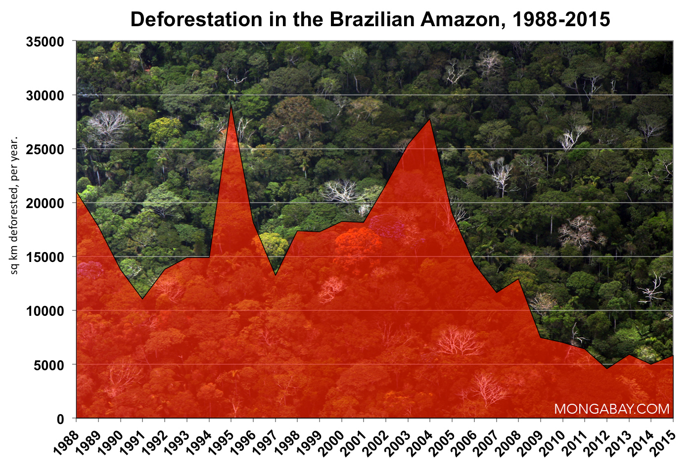
Brazil once had the highest deforestation rate in the world and as of 2005 still has the largest area of forest removed annually. Since 1970, over 600,000 square kilometers (232,000 square miles) of Amazon rainforest have been destroyed.
Despite reductions in the rate of deforestation in the last ten years, the Amazon Rainforest will be reduced by 40% by 2030 at the current rate. Between May 2000 and August 2006, Brazil lost nearly 150,000 square kilometers of forest, an area larger than that of Greece.
Effects
One of the major concerns arising from deforestation in Brazil is the global effect it produces on climatic change. The rainforests are of vital importance in the carbon dioxide exchange process, and are second only to oceans as the most important sink on the planet to absorb increasing atmospheric carbon dioxide resulting from industry.
The most recent survey on deforestation and greenhouse gas emissions reports that deforestation in the Brazilian Amazon is responsible for as much as 10% of current greenhouse gas emissions due to the removal of forest which would have otherwise absorbed the emissions having a clear effect on global warming. The problem is made worse by the method of removing the forest where many trees are burned to the ground emitting vast amounts of carbon dioxide into the atmosphere, not only affecting air quality in areas of Brazil but affecting the carbon dioxide levels globally in addition as a result.
Though the fires are only intended to burn limited areas of forest to make way for allocated agricultural plots, they frequently burn much more extensive areas of land than intended. In 1987 between July and October, about 19,300 square miles (50,000 km²) of rainforest was burned in the states of Pará, Mato Grosso, Rondônia, and Acre releasing more than 500 million tons of carbon, 44 million tons of carbon monoxide, and millions of tons of nitrogen oxides and poisonous chemicals into the atmosphere] In 2005 the burning of the forests in Brazil created widespread health implications across the Amazon region, including airport closings and hospitalizations from smoke inhalation.
Carbon present in the trees is essential for ecosystem development and plays a key role in the regional climate in Brazil and also globally. Fallen leaves resulting from deforestation leaves behind a mass of dead plant material known as slash, which on decomposition provides a food source for invertebrates which has the indirect effect of increasing atmospheric carbon dioxide levels through respiration and microbial activity.[ Simultaneously the organic carbon within the soil structure becomes depleted and the presence of carbon plays a vital role in the functioning of life in any ecosystem.
The Brazilian rainforest is one of the most biologically diverse regions of the world. Over a million species of plants and animals are known to live in the Amazon and many millions of species are unclassified or unknown. With the rapid process of deforestation the habitats of many animals and plants that live in the rainforests are under threat and species may face extinction. The deforestation has the effect of reducing a gene pool amongst species meaning that there is less genetic variation that is needed to adapt to climate change in the future. The Brazilian Amazon is known to possess a vast resource for the treatments of medicines and scientific research into the basin has been conducted to find a cure for major global killers such as AIDS, cancer, and other terminal diseases.
Rainforests are the oldest ecosystems on earth. Rainforest plants and animals continued to evolve, developing into the most diverse and complex ecosystems on earth. Living in limited areas, most of these species are endemic, or found nowhere else in the world. In tropical rainforests, it is estimated that 90% of the species that exist in the ecosystem reside in the canopy. Since the tropical rainforests are estimated to hold 50% of the planet’s species, the canopy of rainforests worldwide may hold 45% of life on Earth. The Amazon rainforest borders 8 countries, it has the world’s largest river basin and the source of 1/5 of the Earth’s river water. It has the world’s highest diversity of birds and freshwater fish. The Amazon is home to more species of plants and animals than any other terrestrial ecosystem on the planet—perhaps 30% of the world’s species are found there. More than 300 species of mammals are found in the Amazon, the majority of which are bats and rodents. The Amazon basin contains the largest number of freshwater fish species in the world—more than 3,000 species. More than 1500 bird species are also found there. Frogs are overwhelmingly the most abundant amphibians in the rainforest. Interdependence is where all species are to some extent dependent on one another. Biological interdependency takes many forms in the forest, from species relying on other species for pollination and seed dispersal to predator-prey relationships to symbiotic relationships. Each species that disappears from the ecosystem may weaken the survival chances for another, while the loss of a keystone species—an organism that links many other species together—could cause a significant disruption in the functioning of the entire system.
The removal of the forest by developers affects the social and economic lives of the indigenous people who live in the forests whose families have lived their in relative isolation for many centuries. The rainforest is their home, and a fundamental source of food, shelter, fuel, nourishment and also their cultural heritage and recreation. Deforestation and removal of the forest specifically for the export of timber also removes a valuable protection of the soils in a dynamic ecosystem and the region prone to desertification and silting on the river banks as rivers become clogged with washed away soils in sparse areas. If too much timber is cut, the soil that once had sufficient cover often gets baked and dried in the sun, becoming subject to erosion and degradation of soil fertility meaning that farmers cannot profit from the land even after removal. According to the United Nations Environmental Programme (UNEP) in 1977, deforestation is a major cause of desertification and in 1980 UNEP estimated that desertification threatened 35 per cent of the world's land surface and 20 per cent of the world's population.
The exploitation of the forests in Brazil for mining activities such as gold mining has also significantly increased the risk of mercury poisoning and contamination of the ecosystem and water. Mercury poisoning can affect the foodchain and impact upon wildlife both on land and in the rivers but can also affect plants and affect the crops of farmers who are also looking to exploit areas of the forests. Pollution may result from mine sludge and affect the functioning of the river system at a time when soils are blown away due to exposure and have a significant impact on aquatic populations further implicated by dam building in the region. Dams build in areas of previously inhabited forest may have a profound impact on migrating fish and ecological life and leave the plains prone to flooding and leaching.
| Period | Estimated remaining forest cover | Annual forest | Percent of 1970 | Total forest loss |
| Pre–1970 | 4,100,000 | — | — | — |
| 1977 | 3,955,870 | 21,130 | 96.5% | 144,130 |
| 1978–1987 | 3,744,570 | 21,130 | 91.3% | 355,430 |
| 1988 | 3,723,520 | 21,050 | 90.8% | 376,480 |
| 1989 | 3,705,750 | 17,770 | 90.4% | 394,250 |
| 1990 | 3,692,020 | 13,730 | 90.0% | 407,980 |
| 1991 | 3,680,990 | 11,030 | 89.8% | 419,010 |
| 1992 | 3,667,204 | 13,786 | 89.4% | 432,796 |
| 1993 | 3,652,308 | 14,896 | 89.1% | 447,692 |
| 1994 | 3,637,412 | 14,896 | 88.7% | 462,588 |
| 1995 | 3,608,353 | 29,059 | 88.0% | 491,647 |
| 1996 | 3,590,192 | 18,161 | 87.6% | 509,808 |
| 1997 | 3,576,965 | 13,227 | 87.2% | 523,035 |
| 1998 | 3,559,582 | 17,383 | 86.8% | 540,418 |
| 1999 | 3,542,323 | 17,259 | 86.4% | 557,677 |
| 2000 | 3,524,097 | 18,226 | 86.0% | 575,903 |
| 2001 | 3,505,932 | 18,165 | 85.5% | 594,068 |
| 2002 | 3,484,538 | 21,394 | 85.0% | 615,462 |
| 2003 | 3,459,291 | 25,247 | 84.4% | 640,709 |
| 2004 | 3,431,868 | 27,423 | 83.7% | 668,132 |
| 2005 | 3,413,022 | 18,846 | 83.2% | 686,978 |
| 2006 | 3,398,913 | 14,109 | 82.9% | 701,087 |
| 2007 | 3,387,381 | 11,532 | 82.6% | 712,619 |
| 2008 | 3,375,413 | 11,968 | 82.3% | 724,587 |
(Source:: Wikipedia)
Commentary by Virgilio Viana, special to mongabay.com
January 30, 2011
Two big events happened in Cancun. The first was the Conference of the Parties (COP) which dealt with negotiations on the future of the United Nations Framework Convention on Climate Change (UNFCCC). This is the official COP’s annual event. The results were limited considering the urgency and the severity of global climate change. Not many surprises, unfortunately.
The other event could be called “Global Conference on Climate Changes and Sustainable Development.” There were several discussions, symposiums, workshops and meetings which were held in hotels all over Cancun. Formally these events are known as “side-events” at COP.
Different from the main event, these side-events were a huge success. It was possible to see the dynamism and innovation potential of national and sub-national governments, companies, social movements, research institutions, and other leaders. Events highlighted all kinds of technological breakthroughs by researchers and companies. Local, regional, and national leaders discussed complex issues without the formalities of the official negotiations.
|
|
|

Good news came from Indonesia, which has launched an ambitious deforestation reduction program, as well as a paradigm shift towards a green economic development. Forest certification systems saw huge progress and overcame methodological issues. Big global enterprises supported sectorial agreements to track their supply chain and diminish their carbon footprint. NGOs introduced great innovations to combine poverty alleviation and nature conservation. Investors showed themselves more prepared to invest in green businesses. Multilateral agencies presented great outcomes as well – south-south partnerships have become a new source of hope and optimism. New alliances and pacts have broken paradigms, sectarianism and old prejudices – we are witnessing the birth of a new global alliance.
The overall message from these side-events was: “independent of the COP process, we have decided to act now.” What inspired the progress? Perhaps it was the frustration of trying to work through the official process, the vulnerability of the private sector to civil society pressure, or the economic opportunities presented by climatic, social, and environmental issues. Whatever the cause, what is clear is that from now on, we shall pay close attention to the outcomes from the Global Conference about Climate Changes and Sustainable Development. The next will be in South Africa, at the end of 2011, and then Rio de Janeiro in 2012. These will be great opportunities for new leaderships with practical, audacious and innovative actions towards a green economy.
Comments: The other side of Cancun: progress
Excellent article.
About Cancun meet, Environmental campaigners feel it threw a lifeline to efforts to get a deal to tackle climate change but there was still much work to do, in particular to close the "gigatonne gap" between the greenhouse emissions cuts countries have pledged and the reductions needed to limit temperature rises to no more than 2C.
The agreement acknowledges the need to keep temperature rises to 2C and brings non-binding emissions cuts pledges made under the voluntary Copenhagen Accord, hammered out in the dying hours of last year's conference, into the UN process.
It also includes an agreement to set up a green climate fund as part of efforts to deliver 100 billion US dollars (£60 billion) a year by 2020 to poor countries to help them cope with the impacts of global warming and develop without polluting.
It includes a scheme to provide financial support for countries to preserve their forests, in a bid to combat deforestation which accounts for almost a fifth of global annual emissions, and makes progress on how countries' actions are going to be monitored and verified.
Earlier progress had been held up by the major stumbling block of what is to be done about the existing climate treaty, Kyoto protocol, and how major emitters such as the US and China should be included in a future deal.
Cancun meet did give hope on measures to contain climate change.
Dr.A.Jagadeesh Nellore (AP), India
Dr.A.Jagadeesh
3 February 2011
Is Obama's clean energy revolution possible?
Jeremy Hance
mongabay.com
January 26, 2011
Recent studies point to the feasibility of a global clean energy revolution.
Last night US President Barack Obama called for a massive green energy make-over of the world's largest economy. Describing the challenge as 'this generation's Sputnik moment' the US president set a goal of producing 80 percent of America's energy by clean sources by 2035. While this may sound improbable, two recent analyses back the president up, arguing that a global clean energy revolution is entirely possible within a few decades using contemporary technology and without breaking the bank.
"Based on our findings, there are no technological or economic barriers to converting the entire world to clean, renewable energy sources," Mark Z. Jacobson, a professor of civil and environmental engineering at Stanford said in a press release. "It is a question of whether we have the societal and political will."
Political will has been difficult to come by, especially in the US where comprehensive climate legislation failed to pass last year, and the nation still refuses to sign on to the Kyoto Treaty, although it has become a more proactive participant in international negotiation under the Obama Administration.
| |
|

Yet, according to Jacobson's paper published in Energy Policy, not just the US's, but the entire world's energy needs could be met by electricity produced 90% from wind and solar sources alone. The final 10% could be generated by geothermal, hydro, wave, and tidal power. Ground transportation would be run by electricity or hydrogen fuel cells, and planes would be powered by liquid hydrogen. Since electricity is far more efficient than combustion, the world would see a 30% decrease in energy demand simply by switching to electric power.
In this truly revolutionary scenario, natural gas, coal, and oil would become energy sources of the past by mid-century.
Jacobson's timeline isn't too different from Obama's. The study finds that all new energy sources would be green by 2030, while all sources of energy could become green by 2050.
But what would this cost? Nay-sayers have argued for decades that it is simply too costly to switch to green energy. However, according to the researchers and a number of previous studies, the cost would not be much different than what society is paying today.
"When you actually account for all the costs to society—including medical costs—of the current fuel structure, the costs of our plan are relatively similar to what we have today," Jacobson said who factored into the cost the lives saved—2.5 to3 million people every year—by the massive reduction in air pollution from ridding society of fossil fuels.
| |
|

In order to overcome legitimate concerns about the variability of wind and solar energy, the authors say that various energy sources should be packed together.
"The most important thing is to combine renewable energy sources into a bundle," Jacobson explains. "If you combine them as one commodity and use hydroelectric to fill in gaps, it is a lot easier to match demand. […] With a system that is 100 percent wind, water and solar, you can't use normal methods for matching supply and demand. You have to have what people call a supergrid, with long-distance transmission and really good management."
Finally, the study found that worries that wind and solar power would require too much land were overblown.
"Most of the land between wind turbines is available for other uses, such as pasture or farming," Jacobson said. "The actual footprint required by wind turbines to power half the world's energy is less than the area of Manhattan."
Although Jacobson's utopian vision of a green energy within a few decades may appear hard to believe, a series of studies by the UN Industrial Development Organization (UNIDO) has also found that a similar energy transformation is quite feasible, saving the world from the worst impacts of climate change.
According to the study a combination of a green energy boom, improvements in efficiency, and carbon capture and storage could meet the international community's goal to avert the world warming over two degrees Celsius. After last year's climate warnings—2010 witnessed a number extreme weather events linked to climate change, and saw record melting in Greenland, and tied for the hottest year on record—the UNIDO reports are an optimistic respite from increasingly grim news on the climate.
| |
|

According to the UNIDO studies, a green energy revolution could provide a quarter of the cuts needed by 2050, while another quarter would come from energy efficiency improvements, especially in developing nations. The rest of the emissions cuts required would then come from carbon capture and storage.
"This technology is rapidly evolving not only for power plants but also for a wide range of industrial applications," writes the UNIDO.
In regards to cost, UNIDO agrees with Jacobson's study that clean energy can compete with fossil fuels. However, UNIDO found one caveat.
"Renewables are not cost competitive where fossil fuels are subsidized. They are, however, already cost competitive in many cases and many countries with unsubsidized fossil fuels," explains the UNIDO.
As of last year the world spent $500 billion on subsidies for oil, gas, and coal, which David Victor, a professor of political science with UC San Diego's School of International Relations and Pacific Studies, at the time called mostly "a complete waste of money".
President Obama appeared to agree last night during his State of the Union. He pledged to end subsidies to oil companies and move these funds to support the American green energy revolution he envisions.
Still, Jacobson adds that while a green energy revolution is technologically and economically feasible, it will by no means be easy.
"This really involves a large scale transformation. It would require an effort comparable to the Apollo moon project or constructing the interstate highway system." Jacobson says, using the space-race metaphor that Obama also employed. "But it is possible, without even having to go to new technologies. We really need to just decide collectively that this is the direction we want to head as a society." Comments: Is Obama's clean energy revolution possible?
Because of commitment of President Obama on Green Technologies,it is opossible to lay firm foundation to achieve the goal.
Here is an interesting article on the subject:
nuclear-news latest news on the uranium/nuclear industry Future for renewable energy looking good in USA and elsewhere
"Whatever the outcome of the upcoming mid-term elections in the country, [USA] the present momentum to create renewable energy opportunities looks likely to have broad bipartisan support….Even as the country was combating the downsizing of its economy and the job losses spawned by it, “more renewable energy capacity was installed than conventional fossil or nuclear power stations,” according to a recent report by Bank Sarasin, the Swiss financial institution.
Bright future for renewable energy Not only US and Europe are creating opportunities but also rest of the world gulfnews By Manoj Nair, October 24, 2010 Dubai : Barack Obama might have been less than enthusiastic recently about installing new solar panels at the White House, but this has in no way deterred the US from committing a growing cache in alternate energy resources.
Whatever the outcome of the upcoming mid-term elections in the country, the present momentum to create renewable energy opportunities looks likely to have broad bipartisan support.
And US politicians are likely to keep to the straight and narrow when it comes to alternate energy — public anger and dismay over the havoc wrought by the oil spill in the Gulf of Mexico is too recent to have them think otherwise. In fact, investments attracted by non-fossil fuel initiatives has been on a high for the last two years. Surprisingly so, at that.
Even as the country was combating the downsizing of its economy and the job losses spawned by it, “more renewable energy capacity was installed than conventional fossil or nuclear power stations,” according to a recent report by Bank Sarasin, the Swiss financial institution.
The report — ‘Renewable Energies” Evolving from a Niche to a Mass Market’ — finds that the year-on-year increases were higher by 50 per cent in the US.
It was not a trend confined to the US. New capacity generated by renewable energy sources — including solar cells and modules, wind turbines, etc. — recorded a 60 per cent gain in Europe on a year-on-year basis. Emerging categories such as bio-fuels geo-thermal efforts within the renewable energy umbrella are getting their due as well.The Bank Sarasin report reckons that a substantial 130 billion euros (Dh666.24 billion) was spent in such capacities worldwide, a 23 per cent gain over the 2008 numbers. What is particularly noteworthy is that all of this was taking place when governments and businesses were scrambling to save each dollar.
If renewable energy could attract this scale of investments in a year of recession, there’s nothing to indicate it will not be the same when the global economy is feeling more sanguine.
Even in the Middle East, governments have taken the lead in setting the agenda on renewable energy. One need look no further than Abu Dhabi’s Masdar City initiative, even if its scale has been trimmed down to be more aligned with the economy".
Dr.A.Jagadeesh Nellore(AP),India
Dr.A.Jagadeesh
Jeremy Hance
mongabay.com
January 20, 2011
In 1206 AD Genghis Kahn began the Mongol invasion: a horse-crazed bow-wielding military force that swept through much of modern-day Asia into the Middle East and
"It's a common misconception that the human impact on climate began with the large-scale burning of coal and oil in the industrial era," says Pongratz, lead author of the study in a press release. "Actually, humans started to influence the environment thousands of years ago by changing the vegetation cover of the Earth‘s landscapes when we cleared forests for agriculture."
The answer to how this happened can be told in one word: reforestation. When the Mongol hordes invaded Asia, the Middle East, and
In the study published in The Holocene, Pongratz along with Carnegie colleague, Ken Caldeira, and German colleagues at the Max Planck Institute for Meteorology, compiled a model of global land cover beginning in 800 AD. She kept her eye on four historical events closely, which she theorized could have impacted the climate due to the return of forests after depopulation: the Black Death in Europe (the end of the 14th Century), the fall of China's Ming Dynasty (the last half of the 17th Century), the conquest of the Americas (the 16th and 17th Centuries), and the Mongol invasion of the 13th and 14th Century.
"We found that during the short events such as the Black Death and the Ming Dynasty collapse, the forest re-growth wasn't enough to overcome the emissions from decaying material in the soil," explains Pongratz. "But during the longer-lasting ones like the Mongol invasion and the conquest of the
The Mongol invasion had the most significant impact. According to the study's accounting, re-growth of forests during the Mongol invasion absorbed 700 million tons of carbon from the atmosphere, equaling the amount of carbon global society now produces annually from gasoline.
Pongratz argues that her study has relevance for the world's current climate crisis: "Today about a quarter of the net primary production on the Earth’s land surface is used by humans in some way, mostly through agriculture. […]. In the past we have had a substantial impact on global climate and the carbon cycle, but it was all unintentional. Based on the knowledge we have gained from the past, we are now in a position to make land-use decisions that will diminish our impact on climate and the carbon cycle. We cannot ignore the knowledge we have gained."
Of course, before society can even consider global reforestation, global deforestation must be halted. Despite worldwide concern and numerous initiatives over the years (both local and global) forests continue to fall at staggering rates. Currently around 10% of the world's greenhouse gas emissions come from deforestation.
Genghis Kahn statue.
Comment
Yes. In the past Kings realised the importance of biological control of nature by planting trees. Ashoka is known for his concern and commitment to grow trees to maintain ecological balance.
In modern times
Here are more details:
Afforestation in North China Helps Harness Desertification and Soil Erosion
The windbreaker belt project in northeast, north and northwest
Spreading out in 551 counties in 13 provinces (autonomous regions and cities) in the three regions the project covers an area of 4.069 million square km, accounting for 42.4 percent of
Starting from 1978, the project, divided into three phases and eight large projects with construction period lasting 73 years, is expected to bring to finish in 2050 and to turn 35.6 million ha of land into the woodland.
The target of the project is to increase the forest coverage from the current 5.05 percent to 14.95 percent in the three regions with the land desertification and soil erosion brought largely under control, ecological environment and people's living condition greatly improved.
So far, the project has fulfilled the first three phases in the construction. After trees are growing into forest, the forest coverage in the three regions will be increased to 10 percent. Windbreakers in Beijing, Tianjin municipalities, and Liaoning, Jilin, and Heilongjiang provinces have by and large formed a wind-shelter belt. Ecological environment has been greatly improved, thus promoting the economic development in rural areas along with the raising of the people's living standard.
A shelter of 10-million ha from Xinjiang to
A total of 2.4 million ha of forest for farmland and 4 million ha for economic forest have been planted, and a batch of fine fruit bases has been set up with total production value topping 25 billion yuan. All these have greatly promoted the economic development in the rural areas and raised the earnings of farmers.
By PD Online Staff Member Li Yan
(Xinhua)
2010-08-18
The central government spent 233.2 billion yuan on the 415 million mu (27.7 million hectares) of new forests planted from 1999 to 2009, said Wu Lijun, head of afforestation in the SFA, at a press conference in Beijing.
Among the total, 139 million mu were farmland returned to woodlands, Wu said.
Since the government started to subsidize farmers who return their farmland to woodland in 1999 to combat soil erosion in central and west
In
Dr.A.Jagadeesh Nellore(AP),
No comments:
Post a Comment